Annexation 2018 - What You Need to Know Before You Vote
The the attachment Below Annexation 2018 to learn about:
- Annexation: City's History
- Annexation Ballot Question
- Annexation: The Facts
Beware of Wrong information on Annexation!!
Here are the Facts:
***Although the TGK Jail is within the boundary line of the annexation,The TGK jail is and will remain county property after annexation. The County maintains control and responsibility for the jail NOT the City.***
***The Florida East Coast Railroad property was deemed “terminal” property by the County and is not part of the annexation.***
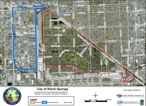
ANNEXATION MAP
The map below shows the 1,018 acres or 1.59 square mile area for annexation, which is contiguous to the City’s current western municipal boundary as shown on this map. This area is located generally south of the NW 74th Street Connector, north of NW 36th Street, east of SR 826 and west of the City’s current western boundary (NW 67th Ave), but excluding the FEC tracts. The Annexation Area comprises mostly industrial and commercial land. The issue of contiguity was settled years ago; the city has contiguity by and through the area of 74th Street. It is important to note that the County does not require contiguity. The FEC property is specifically excluded from the annexation area.
Any Questions Contact:
City of Miami Springs | 201 Westward Drive | Miami Springs, FL 33166 | 305.805.5000
www.miamisprings-fl.gov | Facebook @MiamiSpringsFL | Twitter @MiamiSpringsFL
Instagram @cityofmiamisprings | YouTube City of Miami Springs-Government